PERCORSO VALLE DEL VERDE

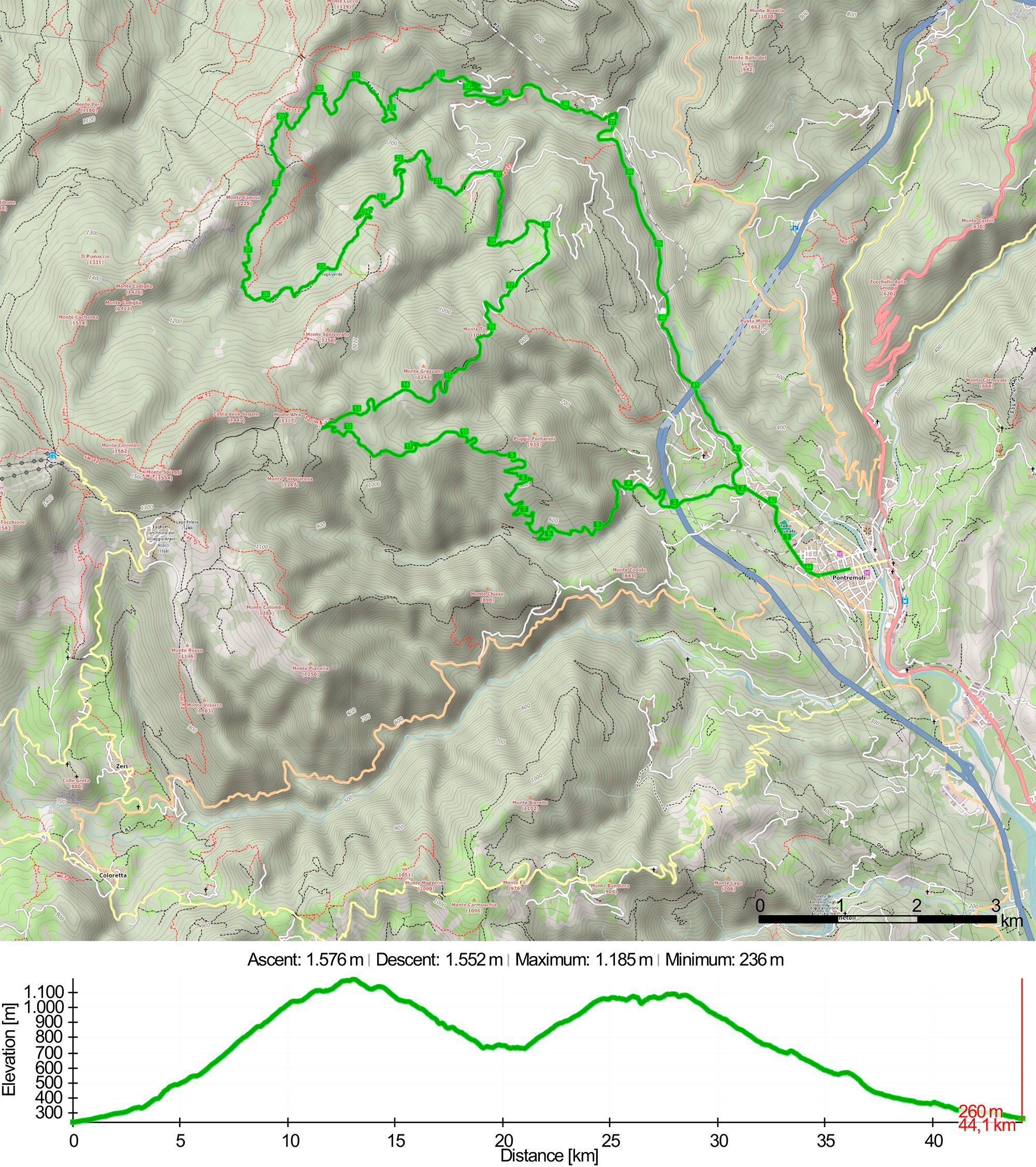
Il percorso della Valle del Verde è sicuramente il più impegnativo tra i 6 percorsi che vi proponiamo. Da Piazza Italia si procede su via Roma in direzione del campo sportivo Lunezia per poi arrivare a Casa Corvi dopo 2 km. Da qui si procede verso la frazione di Bassone dove inizia una lunga salita sterrata di quasi 9 km con una pendenza media dell’8.5%.
Circa al tredicesimo km si raggiunge il punto piĂą alto del percorso (1185 mt slm) e da qui inizia una lunga discesa verso la localitĂ Villa Andreetti che raggiungerete dopo circa 5 km. Svoltando a sinistra sempre in discesa dopo il ventesimo km si raggiunge il paese della Cervara dove la strada torna a salire verso il Lago Verde e il torrente Verde.
Al km 26 dovrete affrontare una breve ma ripida discesa che dalla fine della strada sterrata vi farà raggiungere il greto del torrente Verde. Poco distante da questo punto, risalendo il corso d’acqua, potrete ammirare la bellissima cascata del Verde con la sua acqua gelida anche in piena estate.
Oltrepassato il torrente avrete raggiunto la localitĂ FarfarĂ che dista solo 2 km dal bivio per Fontana Gilenta (fontana ghiacciata) da dove ha inizio la lunga discesa verso Pontremoli. I primi 5 km saranno su strada sterrata e i restanti 11 su asfalto.
Lungo questa discesa attraverserete i paesi Monti di Guinadi, Baselica e Guinadi, prima di ritrovare Casa Corvi e fare rientro a Pontremoli dopo 44.1 km e 1576 mt di dislivello.
Valle del Verde Route is the most demanding track among those we propose. From Piazza Italia you proceed along Via Roma, past the Lunezia sports field to Casa Corvi, about 2km from the starting point. Then you proceed towards Bassone where a long climb begins on a dirt road of about 9km with an average slope of 8.5%.
At the 13th km you reach the highest point of the route (1185m MSL), where a long descent begins towards Villa Andreetti which you will reach after about 5km. Turning left, always sloping down, you reach the village of Cervara where the road goes up to Lake Verde and the Verde creek.
At the 26th km you will have to face a short but steep slope that will take you to the pebbly bed of the Verde creek. Not far from this point, going up the creek, you can admire the beautiful Verde waterfall characterized by freezing water even in summer.
After crossing the stream you will reach FarfarĂ , which is only 2 km from the junction for Fontana Gilenta (icy fountain) from where a long descent towards Pontremoli begins. The first 5km are on a dirt road and the remaining 11Km on paved roads.
This slope passes through the little villages of Monti di Guinadi, Baselica and Guinadi before to reach Casa Corvi and then back to Pontremoli after 44.1 km and 1576m of cumulative elevation gain.
GALLERY


Just for fun